|
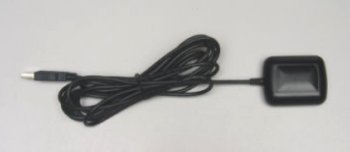
GPS Option (WR-G3E-GPS)
|
This hardware/software option consists of an integrated GPS receiver and antenna (with USB interface) and
application mapping software with a high-resolution world map licensed by NASA. When combined with the G33EM receiver,
this option provides a continuous position display, superimposed on a zoomable high-resolution map of the world.
Logging course co-ordinates into a ".csv" file is also provided, with user-definable logging intervals.
|
|
|
Technical Specifications
|
| General |
L1 frequency 12-channel continuous tracking |
| Update rate |
1 Hz |
| Sensitivity |
-170 dBW |
| Accuracy of position |
15 m (without Selective Availability) |
| Accuracy of velocity |
0.1 m/s (without Selective Availability) |
| Accuracy of time |
1 ms |
| Datum |
WGS-84 |
| Cold start time |
60 s |
| Warm start time |
38 s |
| Hot start time |
8 s |
| Reacquisition of signal |
1 s |
| Maximum altitude |
18,000 m |
| Maximum velocity |
515 m/s |
| Maximum motional jerk |
20 m/s3 |
| Maximum acceleration |
4G (39.2 m/s2) |
| Operating temperature |
-30şC – 80şC |
| Storage temperature |
-40şC – 85şC |
| Humidity |
Max. 95% non-condensing |
| Interface |
USB |
| Power |
5V ±5%, 90mA (via interface) |
| LED indicator |
OFF: Power OFF
ON: Searching
FLASHING: Position fixed |
| GPS output protocol |
NMEA 0183 SiRF binary: position, velocity, altitude,
status |
| Serial transfer protocol |
User configurable (default 4800,N,8,1) |
| Cable length |
1800 mm |
|
Dimensions
|
59 mm (L) x 47 mm (W) x 21 mm (H)
|
|
Package
|
Water-proof with non-slip magnetic base
|
Specifications are subject to change without notice due to continuous product development and improvement.
|
|
|